While it is generally accepted that the 1637 land patent to one Robert Rockhould (Rockwell), for the arrival of himself, his wife Sarah and daughter Mary, and one Thomasin Rockhould and a Mary Sayo? is the beginning of our family in America. I have questioned whether Thomasin was Robert's son or maybe his mother.
I found the following on line: While there is always question as to the accuracy of transcribed historical documents, I now am more convinced that Thomasin was Robert's mother. Thomas arrived in 1639, after the original immigrants. I suspect the Mary Roe might have been a servant or some connection and she brought Thomas to the new world. I still need to search the eitire document for any others that Robert might have sponsored in the '37 - 40 time frame.
I have only extracted those names I have found interest in, the Boatwright might connect to my mother's family, and any of the Richardsons might connect to Mary, wife of Robert's son John; both Learward and Leonard arrived in Norfolk.. I still have not found the Mary Sayo? (or whatever her name is) that is listed on the 1637 land patent.
New Norfolk,Upper Norfolk,and Namsemund are all pretty much the same, there were several name changes in the '37-'40 time frame. You can view the entire transcript at the web site below.
http://www.evmedia.com/virginia/
Complete listing of
Early Virginia Immigrants, 1623-1666
(from book published 1912 by George Cabell Greer, now copyright-free)
Each line contains from left to right:
LAST & FIRST - Name of immigrant who came to America
ARRIVAL - Year of immigrant arrival
SPONSOR - Name of sponsoring person(s) paying passage of immigrant
COUNTY - County in which sponsor received land for payment of passage
"There are over 17,000 names of immigrants and over
25,000 names including the sponsors. The original book had many alphabetizing errors,
which have been corrected with computerized sorting.
Scanning the 300+ pages and correcting the many errors has been a labor of love as
partial repayment for those genealogists (professional and non) who have given me gifts.
Allen Price, 2011"
LAST FIRST ARRIVAL SPONSOR COUNTY
Boatwright John 1654 Humphry Dennis Gloucester
Rockwell Mary 1637 Robert Rockwell New Norfolk
Rockwell Sarah 1637 Robert Rockwell (husband) New Norfolk
Rockwell Thomas 1639 Robert Rockwell Upper New Norfolk
Rockwell Thomasin 1637 Robert Rockwell New Norfolk
Roe Mary 1639 Robert Rockwell Upper New Norfolk
Richardson Barbary 1653 Major Abraham Wood Charles City
Richardson Bridgett 1639 Ralph Barlowe Northampton
Richardson Dorothy 1655 Richard Price New Kent
Richardson Evan 1648 Thomas Ludwell James City
Richardson Isaac 1650 Wingfield Webb & Richard Pate ???
Richardson Isabell 1642 Hugh Gwyn ???
Richardson John 1650 James Williams ???
Richardson Learward 1637 Henry Catalyn New Norfolk
Richardson Leonard 1638 Henry Catelyn Upper Norfolk
Richardson Luke 1636 John Chandler Elizabeth City
Richardson Mary 1645 Bartholomew Hoskins ???
Richardson Nicholas 1655 Jervace Dodson Lancaster
Richardson Peter 1638 Capt Christopher Wormley ???
Richardson Peter 1651 Capt Stephen Gill Northumberland
Richardson Robert 1639 Thomas Faulkner ???
Richardson Robert 1655Thomas Peck Gloucester
Richardson Symon 1636William Clarke Henrico
Richardson Thomas 1650Capt Moore Fautleroy ???
Richardson Thomas 1638Christopher Branch Henrico
Richardson Thomas 1642Daniell Lewellyn ???
Richardson Thomas 1642Thomas Bagwell Isle of Wright
Richardson Thomas 1643William Warder ???
Richardson Mary 1649 Rowland Burnham ???
Richardson William 1637 William Farrar Henrico
Tuesday, December 17, 2013
Wednesday, November 6, 2013
Distant Family Relations
Watching the TV series "Reign" and I remembered that my mother's line connected back to the Stuart line in Scotland. Then, I began to wonder if I had any connection to the "royal" Stuart family. Well, turns out that if I go back seven generations before Queen Mary, to her (I think) fifth great grand father; Robert de Bruce Stuart (Robert II, King of Scotland) and Elizabeth Mure I find one. They had twelve children; their son, Robert Stuart, became Robert III, King of Scotland, and Mary's ancester, his sister, Elizabeth Stuart, married Iain Macdomhnaill. And, that is my connection to the Scot's ancient royality.
The Macdomhnaill line became the McDaniel's. And, of that line, Charity McDaniel (1794-1877) married the Frenchman William Humphrys. Their daughter, Charity Melinda, married a cousin, John Daniel McDaniel. Their daughter, Melvina, married Benjamin Mitchell, and their daughter, Emma Geneva Mitchell, was my Grandmother.
It gets a bit complex here: Emma married (first) Robert Ridley Perry, my grandfather, second she married Thomas Blevins, and third to Henry Allen Perry, Robert's brother. Robert remarried Eula Isabel Washburn, widow of John Mitchell who was Emma's brother.
So, my great uncle Henry became my other Grandfather, and great aunt Eula became my other Grandmother. When I look at the lineage of the Stuart and Tudor families of ancient England and Scotland, it don't really look all that bad.
Sunday, October 27, 2013
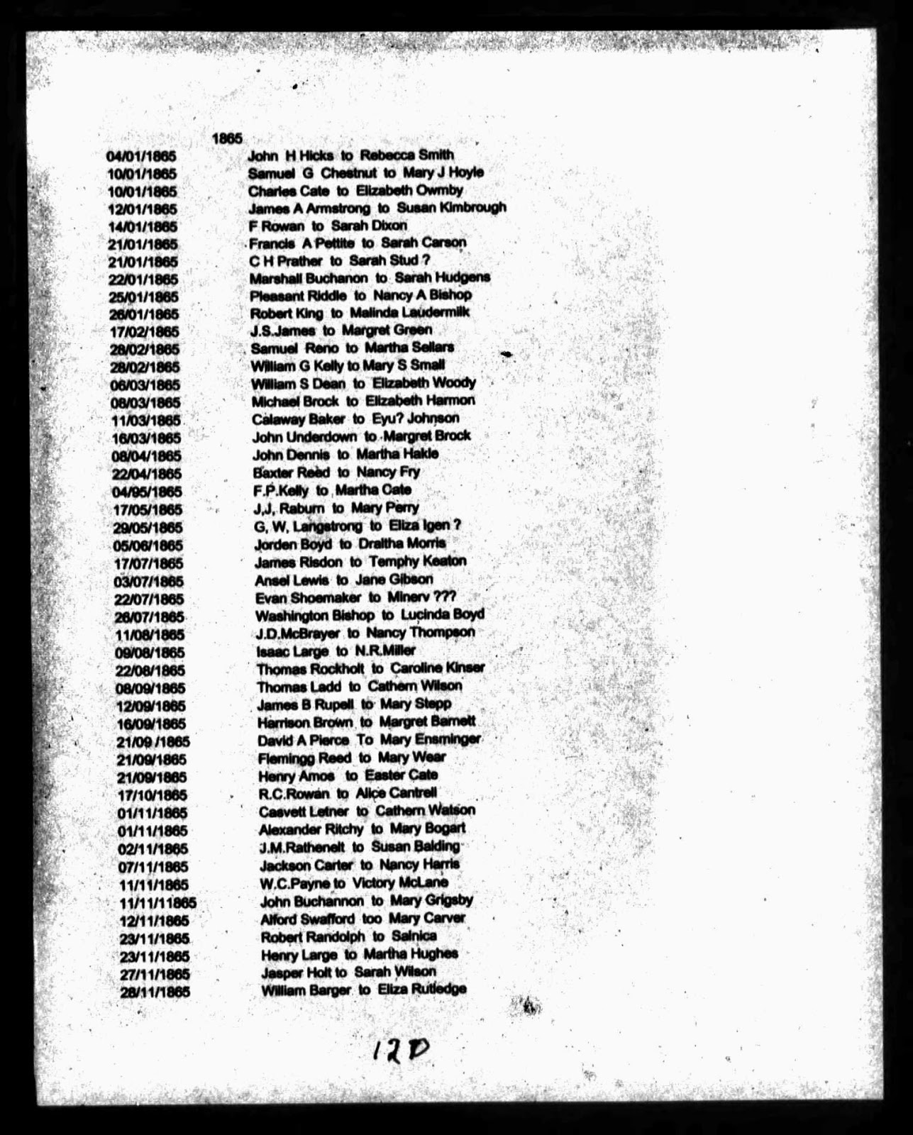
Thomas Rockholt married Caroline Kinsey on August 24, 1865
Thomas Rockholt married Caroline Kinsey on August 24, 1865, McMinn County, Tennessee. There are several good (and not so good) references for this event:
A photo copy of the original county record indicating a marriage license was issued on August 22nd and the marriage was on August 25th, before a justice of the peace.
There is a hand written record, probably the county clerks' book, which shows the same information but is indexed as Caroline Kinser.
A typed sheet, listing 1865 marriages in Tennessee, has Thomas Rockholt and Caroline Kinser married on August 22, 1865,
It appears that the original was probably misread, resulting in the wrong spelling of Caroline's name; the date error is obviously a misreading of the license date for the marriage date. While in this case the differences are not severe, they could certainly result in ones tree having the wrong information. Even with the best research there is always the chance of error -- we can only do our best to get it right.
Now I need to find exactly who Thomas is and where he fits on the family tree. I believe he was born around 1845 and died after 1880. Caroline is actually Rachel Caroline Kinsey.
1880 Dist 3, McMinn County Tennessee Census has Thomas and Rachel C. Rockhold and their children. Also on the same page I find Nancy A. Rockhold (55 YO) living by herself; James R (36 YO) and Katherine F.S. and kids and William and Celia Rockhold and their son Eli. Near the first of the census report I found F.M. and Susannah Rockhold and daughter Mary Josaphine in house number 4.
This Nancy A. Rockholt, living by herself, is probably a widow and at age 55 is about the right age to be the mother of most if not all of the boys on this census. I also see a few "Melton" families on the census, and since I have seen the Rockholt/Melton union before, I suspect this might be Nancy Melton, wife of one William Rockhold/t. I also see there are a few of the Colbough family, which I have also seen married into the family.

.jpg)
.jpg)
Saturday, October 5, 2013
What happened to Town Neck, and Providence, Maryland
We often wonder where our ancestors came from, where they lived and what kind of life they had. Trying to trace our early ancestors to an exact location in Virginia is proving to be impossible. The move to Maryland not so.
Eight persons took out patents in the first settlement of Virginians in Maryland, at Greenbury Point (then called Town Neck) in 1649: William Pell, George Slaughier (Sapher), ROBERT ROCKHOULD, William Penny, Christopher Oatley, Oliver Sprye, John Lordkin and Richard Bennett. The whole tract eventually passed to Bennett and the name finally became Greenbury Point, as it is today.
Early maps of the area indicate that there was more land on Greenbury Point than there is today. Erosion, caused by the flow of the Severn River over the years, has taken away much of the land that our ancestors probably settled when they moved from Virginia. What exists today is part of Naval Station, North Severn, Annapolis, MD, part of the Naval Academy.
Greenbury Point is managed as a conservation area and is used for light midshipmen tactical training. The Radio Transmitter Facility at Greenbury Point was ordered to close, per BRAC '91. The the 231 acres of land and existing facilities, except the towers, at Greenbury Point conservation area at North Severn (formerly the Naval Radio Transmitting Facility (NRTF)) had been transferred to the US Naval Academy in September 1994. The undeveloped areas are being managed as wildlife habitat; therefore, human access is limited. Residents of Greenbury Point housing have free access to their homes and surrounding area except the East and West Roads and undeveloped areas.
During the Cold War, Greenbury Point was a key communications center for the Navy's submarine fleet. The antennas transmitted Very Low Frequency signals capable of penetrating the ocean, allowing communications with submerged submarines. By the early 1990s, with advances in satellite communications, the antennas became obsolete.
The property -- then called "Hammond's Inheritance" -- was purchased by the Navy on August 21, 1909 for use as a dairy farm. From 1911 to 1917, part of this site was also used for the first Naval Air Station. In August 1911 a handful of Naval officers received orders to report for duty at the Engineering Experiment Station at the Naval Academy "... in connection with the test of gasoline motors and other experimental work in the development of aviation, including instruction at the aviation school." The site of the aviation camp at the Academy was Greenbury Point. The Greenbury Point station has not come in for its fair measure of recognition in the history of Naval Aviation. It was a very small affair, and it shared its location with the Academy as its host. Nonetheless, its establishment was a landmark event, It was the Navy's first air station and it was at Greenbury Point that the Navy began to conduct its first formal aviation training program. Pensacola, known as "The Cradle of Naval Aviation," succeeded the "naval air encampment" at Greenbury Point as the training site for naval aviators in 1914.
The Navy first built the four of the most northern radio towers on Greenbury Point in 1918 to communicate with US forces fighting in World War I. The transmitter, with call letters NSS, went on the air on 06 August 1918. The Annapolis transmitters operated in conjunction with a large antenna receiver facility at Cheltenham, MD. Two additional southerly towers were erected at Annapolis in 1922. In August 1938, the erection of three "Eifel Towers" (1G7, 1H7 and 1T9) was completed. In 1941, Building #60 was completed, a 50 kW Low Frequency transmitter was installed and operations established. The station was used for communications with the Atlantic Fleet during World War II.
Extensive modification and improvement of the VLF antenna system was begun in 1969. The old 600-foot radio towers on Greenbury Point were demolished to make way for a new communications link with vessels of the Atlantic fleet. A new 1200-foot guyed center tower was erected and surrounded with nine 600-foot towers (three of which were identical to those erected in 1917). The modified "Goliath" antenna consisted of the 1200-foot tower and the "top hat" assembly supported by the 600-foot towers, covering about 200 acres. To power the new VLF antenna a 1000 kilowatt AN/FRT-87 transmitter was installed in the original transmitter building.
Since the radio towers had no operational requirement and the Naval Academy has no mission requirement for the towers, the disposal action for the antenna towers was the responsibility of the Naval Computer and Telecommunications Command (NCTC) under MILCON project P-501.
The demolition of the towers had political implications. A Senate appropriation staffer attempted to allocate funding to this project; however, he also tried to place language in the appropriations bill that would limit the use of the property to only conservation and any changes require Congressional approval. The staffer was informed that this is not acceptable to the Naval Academy.
The demolition of the naval radio transmitting facility (NRTF) towers at Naval Station, Annapolis was initially projected to include demolition and removal of 19 antenna towers, antenna arrays and guys, the excavation and removal of a causeway in the Chesapeake Bay, and incidental related work. The towers to be demolished include: Six 600 foot towers supported by 2 levels of 3 guys, Three 600 foot freestanding Eiffel-style towers, One 1200 foot tower supported by 4 levels of 3 guys, Four 300 foot freestanding towers, One 800 foot tower supported by 1 level of 8 guys, Three 80 foot triangular towers with rigid conical antenna frame supported by rope guys, and One 66 foot freestanding download terminal tower. Six tower guy anchors located in the Bay were removed; and all other tower foundation/anchors and the radial grounding systems remained in place. The base insulator for Tower No. 10 was salvaged and turned over to the Government. The work also included removal of 4 HF curtain array antennas and supports. These include a total of approximately 20 wood pole supports, 55 guy cables, 250 foot (plus or minus) length of 2 foot wide wood access piers, and 60 (plus or minus) wood dolphin poles. The naval station, primary school and golf course remained in operation during the entire demolition period.
The final demolition of 16 of the 19 former Navy radio towers on Greenbury Point took place on 09 December 1999. Three towers remained standing and were turned over to Maryland or Anne Arundel County for telecommunications or training purposes.
The undeveloped area of Greenbury Point is being managed as a environmentally sensitive conservation area and is the surface danger zone for the Naval Station rifle ranges. In the developed area, the facilities are occupied by Construction Battalion Unit 403, a Bachelor Enlisted Quarters, Married Enlisted Quarters (being used as swing space during NavSta BEQ Renovation), and a soon to be renovated Environmental Nature Center.
There are no planned changes to the facilities or land usage at Greenbury Point. An updated Integrated Natural Resources Plan and a Facilities Master Plan are being developed to manage this area. Greenbury Point has a variety of other habitats including wooded coves, shallow wetland ponds, forests and scrub/shrub areas. Many interesting wildlife make this area their home. For example, Greenbury Point supports the only bobwhite quail population in Anne Arundel County, Maryland.
US Fish and Wildlife Service staff developed a Natural Resources Management Plan for the Annapolis Area Complex of the Navy, which includes the Naval Academy, the North Severn Complex of the golf course and Greenbury Point and the Naval Dairy Farm in Gambrills, Maryland. The Service's restoration and environmental education experts assisted the Navy's natural resources manager by evaluating Navy lands and writing a plan for the future of conservation areas and natural habitats under Navy management.
Greenbury Point, the 231 acre peninsula at the mouth of the Severn River, provides numerous opportunities to integrate wildlife habitat and education with the training mission of the Naval Academy. Outdoor education planners from the Service's Blackwater National Wildlife Refuge are lending their expertise to help shape the Visitor's Center Environmental Education facility the Navy is currently building on Greenbury Point. Nineteen osprey pairs that nested on Greenbury Point's radio towers were provided new platforms before the towers were demolished.
Nothing remains of the earliest settlements. Providence, which followed Town Neck's settlement, today is small community of 77 homes, quietly nestled between Mill Creek and the Naval Academy Golf Course on the St. Margaret's Peninsula just outside of Annapolis.
Monday, August 26, 2013
A Little Bit of History
Joshua Pettit was born 25 Sep 1734, Essex, New Jersey; died 11 Sep 1786, Spartanburg, South Carolina. He served with Colonel Roebuck's batallion against the loyalists and the British during the Revolutionary War. Joshua's Grand Daughter Hannah, married Thomas McDaniel; their Grand Daughter Melvina, married Benjamin Mitchell, their Daughter Emma Geneva (Mitchell) Perry was my maternal Grand Mother.
Spartanburg County, South Carolina bears a proud Revolutionary War heritage. The county has more Revolutionary War engagement sites than practically any other locale in the United States. The fiercely independent upstate settlers rallied ‘round the cause' early on, with the Spartan Regiment being formed in the late summer of 1775.
As independent as they were, some could not see the sense in breaking away from the crown. Staunchly Loyalist settlers seethed beside neighbor Patriots. The first engagement seen by local troops involved not a single British soldier. That winter, the Spartan Regiment was bloodied along with other Patriot troops in a fight against regional Loyalists in the Battle of the Great Cane Break, along the Reedy River.
In July 1776, a new threat erupted. Alarmed at the news of a British fleet at Charleston, the Cherokee swept over the frontier borders in a maelstrom of violence. Whites fled to forts, but hundreds of settlers in the border areas were killed before a counterattack could be formed. In early 1777, the Spartan Regiment was split into two - the 1st Spartan Regiment and the 2nd Spartan Regiment.
Colonists all along the western frontier raised a large militia, which pursued the Indian army. As was often the case when European and Indian cultures clashed, many noncombatants suffered. The white militia destroyed scores of Cherokee villages and by mid-1777, Indian aggression collapsed. A treaty was signed in July 1777 forcing the Cherokee to relinquish most of their lands in South Carolina.
The British regained the colonists’ full attention in 1780, when they captured Charleston in May. The Redcoats began their trek inland over three main routes. Initially, the Patriots thought they were whipped. Their situation seemed hopeless, as they faced the might of the greatest military power on earth. Many laid down their arms and surrendered. Benjamin Roebuck did the opposite - he raised his own regiment - Roebuck' s Batallion of Spartan Regiment.
The war very well could have ended then, but for the British’s savage violation of their own terms of surrender. At the Waxhaws at the end of the month, a troop of Virginians were slaughtered after throwing down their arms. Homes of independence-minded Carolinians were burned; their properties seized. The Patriots’ anger rose.
The straw that broke the camel’s back was the British order, in direct violation of their own terms of surrender, that the Patriots don the red coat to serve the crown. The Rebels took the order another way, concluding that the violation of their surrender released them from their parole. The time for peace had past.
The clashes that ignited in the ensuing months in Spartanburg County sent shock waves throughout the world. The area saw six engagements in four weeks, beginning in July with the first battle of Cedar Spring. In quick succession and escalating violence, there quickly followed the battles of Gowen’s Fort, Earle’s Ford, and Fort Prince; then came the second battle of Cedar Spring and the battle of Musgrove Mill. These battles set the stage for two decisive engagements.
Nearly two months later, Patriot forces assembled from several states scored a major victory at the nearby battle of Kings Mountain. The Patriot forces suffered less than 30 killed and some 60 wounded, but the troops of the crown bled red – nearly 160 killed, about 150 wounded and a staggering 760-odd taken prisoner. Most of the crown’s casualties were American Loyalists.
Kings Mountain was a great victory, but it was a merciless one. The British had not seen fit to honor their own terms of surrender. Now 760 men looked to the Rebels for compassion, but they found only hardened hearts. The prisoners were marched to the North Carolina foothills, where the Patriots held a trial and found 36 men guilty of Loyalist atrocities. They were sentenced to hang, though all but nine were pardoned.
Three months after Kings Mountain, the conflict returned in full fury to the Spartanburg County area, when Continental General Daniel Morgan gave British Colonel Banastre Tarleton “a devil of a whipping” at a crossroads known as the Cowpens. The battle at this holding area for cattle being driven to market put the British on the road to surrender at Yorktown.
After the war, some Loyalists fled to Canada. The settlers returned to the land, having subdued both the Cherokee and British threats. More settlements grew up in the area, and the new district began to form its government. Court officers originally met at several plantations, but legislative pressure forced them to choose an official site. In January 1787, they approved the purchase of two acres of land from Thomas Williamson for five shillings. The new courthouse was smack in the middle of the county. The town of Spartanburg was born.
Thursday, August 1, 2013
Early Records
From the early records of
immigrants to the Virginia Colony there can be found a lot of information which
results in creating the confusion of just who did what and when. Robert Rockwell/Rockhould did, on 19 August 1637,
receive a grant of two hundred fifty acres land in Norfolk, Nansemond County,
Virginia Colony. The patent is not very
legible in the copy I have but it appears to be for the transportation of five
(50 acres per person): Robert himself,
his wife Sarah or Hanah, daughter Mary, one Thomasin Rockwell, and Mary
Sayor/Hayor (probably a servant). This
Thomasin might be a son, later called Thomas but I believe it is actually
Robert’s mother and that Thomas the son was actually born in Virginia, as was
Robert Jr. and John.
This patent, 19 August
1637, is the earliest known record.
Considering it is the actual grant of land and not just the
authorization for the land, it may have been issued some time after the family
actually arrived in Virginia. It was not
unusual for several months, even a year or so, between the arrival and the
actual claim for land being made.
If you have anything before this, or some clarification of this patent I sure would like to know about it. I have it in . PNG format and will gladly email it to you if you want to view it better than on this blog. Or, if you have a better copy or what you believe to be a good transcript of it, let me know.

Wednesday, July 31, 2013
What was it like?
At the start of
the seventeenth century the entire eastern portion of North America, which
afterward became the thirteen original states, was known as Virginia. Interest
in American colonization was awakened in England by a little book on
"Western Planting," inspired by Raleigh and written by Richard
Hakluyt. Several voyages were made before any permanent settlement was
established.
These voyages, undertaken by
individuals, were not successful financially or otherwise and others were
deterred from risking their fortunes in similar enterprises. But the success of
various commercial companies which had multiplied in the last half century for
the purpose of trading with distant countries, such as the East India Company,
chartered in 1600, suggested similar enterprises for the western world. And,
the corporation as a form of local subordinate government had long been
familiar to the English merchant, and readily lent itself to plans of colonial
extension.
In 1606, two companies were formed,
Virginia was divided into two parts and a part granted to each, the London
Company and the Plymouth Company. A royal charter enabled each to found a colony, granting them the right to coin money, raise revenue, and to make laws, but still reserving much power to the king. Each was given a block of land a hundred miles square, and the settlements were to be at least one hundred miles apart. The London Company had permission to plant a colony anywhere on the coast between the thirty-fourth and forty-first degrees north latitude.
Great haste was now made by the
London Company in preparing for colonization in America, and on the 19th of
December, 1606, three small ships bearing one hundred and five colonists and
commanded by Christopher Newport, a famous sea captain, set out upon the wintry
sea for the New World. The largest of the vessels, the Susan Constant,was
of one hundred tons burden and the smallest of but twenty tons. The voyage was
long and dreary, and it consumed the remainder of the winter. On reaching the
American shore the weary voyagers were greeted by the singing of birds and the
fragrance of flowers. Entering Chesapeake Bay they named the two projecting
points at its sides, Cape Henry and Cape Charles, after the two young sons of
the king.
They chose one of the great rivers flowing into the bay, left upon it the name of King James and followed it for about thirty miles, and founded a town which also they called Jamestown, after the name of their king. Thus was founded the first of the permanent settlements which were to multiply and expand, and in three hundred years to grow into the greatest nation of the earth. It would be difficult to imagine a set of men less fitted to build a colony and found a nation than were those who settled at Jamestown in 1607. Among them were but twelve laborers, a few carpenters, a blacksmith, a mason, a barber, and a tailor, while more than fifty were "gentlemen," that is men without an occupation, idle, shiftless men who had joined the enterprise without realizing that years of labor were essential to success. But there were a few men of worth in the company. There was Wingfield, who became the first president of of the governing council, the hero of many strange adventures. They soon erected a few tents and small cabins; some, however, found a dwelling place by burrowing into the ground. For a church they nailed a board between two trees, stretched a canvas over it, and beneath this the Rev. Robert Hunt held services according to the rites of the Church of England.
Thus was the beginning.
Subscribe to:
Posts (Atom)